Geoware Tsunami Product List
The TTT (Tsunami Travel Times) CD-R contains specialized software used to calculate first arrival times for tsunamis. Our program is used by numerous organizations to estimate predicted tsunami travel times from bathymetry on a geographic grid. TTT uses the long-wave assumption and employs a 64-node Huygens construction method to solve for the propagation of the wave front. Due to the extensive node-search the resulting travel times are almost free of artifacts caused by the rectangular grid. Significant new improvements in TTT 3.0 included:
USER INTERFACE: TTT 3.2 is a stand-alone, command-line program. This is the most flexible solution since it may easily be invoked from the user's custom user-interface, shell-script, or directly on the command line. TTT returns one of ~25 status flags upon completion, allowing the calling environment to detect error conditions and take appropriate action. The TTT package also comes with the command-line tool TTT_PICK, which can sample the travel-time grid at specified locations where Estimated Times of Arrival (ETA) are requested.
BATHYMETRY DATA: TTT 3.2 is distributed with several versions of global bathymetry, all derived from the latest ETOPO-1 data set . The resolutions of the data sets are 1', 2', 5', 10', 15', 20', 30', and 60'. In addition we supply a global 30" grid derived from SRTM30+. Except for the 30" grid, the courser data sets have been filtered in the slowness domain to avoid aliasing and bias that would result from filtering in the bathymetry domain. Users may also use their own bathymetry grids in the GMT native short integer or float formats.
ANALYSIS AND MAPPING: The free, open source GMT programs are strongly recommended for further grid analysis and general plot making, and for conversion into other grid formats.
All DVD/CD-ROMs are compatible with installations under both Unix/Linux (incl. Mac OSX) and Windows
operating systems.
| TTT CD-R Version 3.2.1 December 2011. | |
|---|---|
 |
This CD-R contains the latest version of the Tsunami Travel Times software. The new version 3.2 provides installations for both Unix/Linux/MacOSX systems and Windows and is fully ANSI-C/POSIX compatible. The CD-R contains premade global bathymetry grids at 30 arc sec and 1, 2, 5, 10, 15, 20, 30, and 60 arc minute resolutions. TTT is independent of GMT; however, GMT is recommended for analysis and plot making. For more details, click here. |
| Unit Price: $ 650.00. S/H adds $ 5.00. Place your order via PayPal. | |
| TTT CD-R Version 3.2.1 December 2011 UPGRADE FROM v 3.1. | |
|
Special $600 discount for registered users of TTT version 3.1. |
| Unit Price: $ 50.00. S/H adds $ 5.00. Place your order via PayPal. | |
| TTT CD-R Version 3.2.1 December 2011 UPGRADE FROM v 3.0. | |
|
Special $350 discount for registered users of TTT version 3.0. |
| Unit Price: $ 300.00. S/H adds $ 5.00. Place your order via PayPal. | |
| TTT CD-R Version 3.2.1 December 2011 UPGRADE FROM v 2.4 or earlier. | |
|
Special $200 discount for registered users of TTT version 2.4 or earlier. |
| Unit Price: $ 450.00. S/H adds $ 5.00. Place your order via PayPal. | |
| Custom Tsunami Travel Time Map for Pacific Basin, Version 1.0. | |
|---|---|
 |
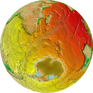
This PDF map shows tsunami travel time contours on top of a beautiful azimuthal equidistant shaded relief map with
seismicity, past tsunamigenic earthquakes locations, plate boundaries, capitals, and large coastal cities.
You specify any coastal city (or location) and Geoware computes the travel time grid and places the custom contours on the map.
The shaded color relief image resolution is 300 dpi at full (A0) size and derives from a 30x30 arc second global relief grid.
You are free to print it at any size you wish, but legends and annotations are most visible if plotted at A3 or larger size.
We will work with you to ensure the correct location, location name, and title are plotted. Choose between two types of copyright:
|
| Unit Price: $ 395.00. RESTRICTED: GEOWARE RETAINS COPYRIGHT. NO SHIPPING, just digital download. Place your order via PayPal. | |
| Unit Price: $ 995.00. OPEN: CUSTOMER RECEIVES COPYRIGHT. NO SHIPPING, just digital download. Place your order via PayPal. | |
| Unit Price: $ 10.00. Add CD-ROM Delivery of PDF via Airmail. Place your order via PayPal. | |
For CDs/DVDs, Shipping/Handling charges include Worldwide Airmail shipping. We recommend you order and pay using your credit card with the above free PayPal service, available from most countries. Alternatively, we accept (1) Company Purchase Orders or (2) Pre-payment by check in US dollars drawn on a US bank (no Eurochecks, sorry), or (3) by bank wire (see details on order form). If you cannot use PayPal, please fill out the order form and preferably (a) send it with your electronic purchase order by e-mail, or (b) print and send it with your purchase order OR check payment to
Geoware, c/o Paul Wessel
91-1350 Kaikohola Street
Ewa Beach, HI 96706-6260
USA
Please contact us should you require more information.

This page was last modified on Tuesday, Nov. 7, 2015.